
Fishbones - Stage 2 - Farsta
The Twists of Brookvale
Friday, August 21
Brookvale Nordic Ski Centre, PEI
The Brookvale nordic ski area is the venue for the second stage of the Fishbones competition. A complex maze of trails zigzag through some lovely island forest is perfect for the mass-start FARSTA-format race. A Farsta is a one person relay - each person runs multiple loops, each loop has lots of forking. A mass start makes for a really fun and exciting head-to-head race, with a high premium for keeping a strong concentration and not getting distracted by lots of runners and controls all over the forest.
SCHEDULE
Registration desk open: 9:00 am - 12:30 am
Mass Start time: 10:00 am *
Max time allowed: 2 hours
Course closes: 12:30 pm
No awards for Fishbones individual stages.
*The Gold Cup Parade is happening in Charlottetown starting at 10 am on the 21st. There are road closures starting at 7 am. We suggest leaving 20 minutes earlier than planned to deal with any traffic/road closure issues. See below for more info.
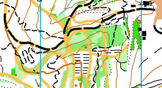
MAP SNIPPET
Brookvale Nordic Ski Centre, PEI
The Brookvale nordic ski area is the venue for the second stage of the Fishbones competition. A complex maze of trails zigzag through some lovely island forest is perfect for the mass-start FARSTA-format race. A Farsta is a one person relay - each person runs multiple loops, each loop has lots of forking. A mass start makes for a really fun and exciting head-to-head race, with a high premium for keeping a strong concentration and not getting distracted by lots of runners and controls all over the forest.
SCHEDULE
Registration desk open: 9:00 am - 12:30 am
Mass Start time: 10:00 am *
Max time allowed: 2 hours
Course closes: 12:30 pm
No awards for Fishbones individual stages.
*The Gold Cup Parade is happening in Charlottetown starting at 10 am on the 21st. There are road closures starting at 7 am. We suggest leaving 20 minutes earlier than planned to deal with any traffic/road closure issues. See below for more info.
MAP SNIPPET
MAP INFO
Brookvale Nordic
ISOM
Scale: 1:7,500
Contours: 5m
Size: 8.5" X 14"
New map: Jeff Teutsch, 2014/2015
Elevation: 50m - 100m (approx)
There is no previous orienteering map of the area, but here is a map of the Nordic Ski trails
COURSE LENGTHS & DETAILS
Click here to see all the course details
TERRAIN DESCRIPTION
Built for the 1991 Canada Winter Games, the Brookvale nordic ski trail network has jammed over 30km of tight, twisting trails into an impossibly small area - this makes for perfect terrain for a Farsta. There is lots of route choice, and a variety of trail types from single track mountain bike tracks to wide skate-ski trails. Cutting through the forest is also a good option in places. Lots of chances to drop your competition in what will be a high-intensity, high-fun, head to head race.
OFFICIALS
Course planner: Adrian Zissos, FWOC
RACE NOTES
There will be a mass start of all classes at 10:00am.
The Mass Start is optional for the following classes:
M/W12, M/W14, Open Beginner, Open Intermediate. These classes may start at any time, using a start punch, if they wish. The concern is that the mass start may be too overwhelming and confusing for the younger and less experienced athletes. Also this allows for shadowing youngsters by an adult after they finish their course.
Point to Point for shorter courses:
The Farsta distance needs to be quite long in order to get appropriate forking. Therefore the shorter classes will have a "normal" point-to-point course. These classes will take part in the mass start but will have only one loop, with no forking. This includes the following classes: M/W12, M/W14, M/W16, M/W75, M/W80, M/W85, Open Beginner, Open Intermediate, Open Advanced.
FARSTA for longer courses:
All other classes (not on a Point to Point course) will be on a Farsta course. This course has three loops each one beginning and ending in the arena. Each loop is printed on a separate map. These three maps are printed on two sheets of paper that you will carry with you. The first two maps will be on one side, and the third map will be on the reverse. At the mass start you begin by running on "Map 1". This will take you on a loop into the forest and then back to the arena. At the end of the first part of your course you switch to "Map 2", follow the flagging to the start, and run that loop. Likewise, after the second loop you switch to "Map 3" and run the final loop. At the end of the final loop you will have a different final control and you run from the last control down the finish chute.
RELAY TIPS - mass starts, following, and forking
Mass starts: To prepare for the chaos of the mass start you must do lots of mental preparation so that you are able to focus on your own navigation and not be distracted by others. To help with this mental preparation, here are two video clips from the absolutely massive Jukola relay ...Video One and Video Two (warning: these take a while to download, but they are worth it).
Following: While following is generally frowned upon in orienteering (actually it is quite against the rules), an exception is made for relays. In fact a lot of the fun of running in a relay is being in a "train" - moving together with other runners much faster than you would if you were alone. Just beware of the forking when a train might split up - make sure you are in the right split...
Forking: This FARSTA has three loops, each of them starting & finishing in the arena. On each loop there is forking, so you might start a loop with someone and have the same three or four controls at the start of the loop (because you are "on the same fork"), but then a new fork might start and you might no longer be on the same fork. I know - it is impossibly difficult to explain. Check out this detailed explanation: FARSTA explained
ARENA INFORMATION
Vendors: The O-Store will likely be on site so you can stock up on your orienteering equipment and supplies.
Food: Bring your own food & snacks.
Water: There will be limited water in the arena. Please bring plenty.
Toilets: Toilets are inside the day lodge. Please, no studs or muddy shoes inside the day lodge!!
Distance & Time from Arena to Start: The start is in the arena.
Distance & Time to Arena from Parking: 100m max.
MAPPER NOTES
Brookvale Provincial Ski Park is the largest Nordic skiing facility in the Maritimes, though only a small part of it has been mapped. With more topography than I knew existed in PEI the provincial park is a beautiful venue for orienteering in addition to the skiing, biathlon, and mountain biking it normally plays host to.
With roughly 25km of ski and mountain-bike trails crammed into the 0.9 square kilometers of mapped forest, trails will undoubtedly feature heavily in your route choices and navigation. That doesn’t, however, mean the orienteering will be easy – in parts of the map there are trails every 20 meters so keeping track of them all will require intense concentration. Note that many of the large ski trails are mapped as linear strips of clearing to represent how they are 5m + wide swaths of mowed grass. Those ski trails with vehicle tracks or paths cutting across or along them are mapped as such.
The forest itself is a mix of managed coniferous forest and wild hardwood forest. In addition to the multitude of trails mentioned above much of this managed forest is criss-crossed with cut lines from logging. Those cut lines that were there prior to mapping are on the map but it is possible more recent logging has taken place and created new cuts that haven’t made it onto the final map.
Some of the forest, particularly the managed portions, is incredibly open and fast, while in other sections the possibility drops to near 0. Underneath the older forest there is a lot of growth of spruce and fir trees that greatly reduce the visibility. This forest underlayer has been mapped in a variety of greens to show the general passability of it. In areas where the trees are spaced far enough apart that you can make your way through them they are mapped in light or medium green whereas when they are dense enough that it is impossible to get through or nearly so, they are mapped as dark green. Individual or tiny clumps of these trees are not mapped but longer thin sections have been mapped so you can plan your routes accordingly.
A final special feature of the area is the piles of old forest debris that has been cleared from the trails and left there in the forest. Most of these are half decomposed and turned to earth but are still quite lumpy and in many cases have different kinds of undergrowth on them. Nonetheless those that are over 1m high are mapped as knolls and some of them are quite a lot higher than that. Those that are under 1m are not mapped.
DIRECTIONS TO ARENA
Parking will be at the Brookvale Nordic Centre day lodge. Turn off Route 13 approximately 1km west of the alpine ski area.
GOLD CUP PARADE IN CHARLOTTETOWN
Be sure to leave your accommodation in plenty of time to get to Brookvale on time. The Gold Cup parade is in Charlottetown on the 21st and starts at 10am. There are road closures. We suggest leaving 20 min earlier than planned to deal with any traffic/road closure issues. If you are staying in Charlottetown, we suggest taking University Avenue or Mt. Edward Road to get out of town.
Road closures will be in place starting at 7 am. Parade route info here.
