
Fishbones - Stage 3 - Chase
Sunday, August 23
Debert, Nova Scotia
The 2015 Maritime Orienteering Festival culminates with the Fishbones Chase. Your total time from the first two stages of Fishbones determine your start time in the chase. All runners within 45 minutes of the leader in their course after the first two stages of Fishbones will be in the Chase. There will be a mass start for all other runners. An early start will facilitate travel plans.
SCHEDULE
Registration desk open: 9:00 am - 12:30 pm
Chasing Starts: first starts are at 10 am
Mass Start time: soon after 10:45
Max time allowed: 2 hours
Course closes: 1:00 pm
All runners completing this, the third Fishbones race, will receive a Fishbones award.
START TIMES
Your start time in the Chase will be determined by your results in the previous two Fishbones races. Your total time after those two races will be compared to the fastest person on your course to give your “time behind course leader”. Your “time behind course leader” will determine when you start in the chase:
We will post start times on the event website shortly after the Fishbones Stage 2 race. We’ll also post them at the Fishbones 3 arena and perhaps in other places. It is your responsibility to get to the start on time. You should be at the start at least 5 minutes before your start time in order to give the officials a chance to start you at the correct time.
MAP SNIPPET
Debert, Nova Scotia
The 2015 Maritime Orienteering Festival culminates with the Fishbones Chase. Your total time from the first two stages of Fishbones determine your start time in the chase. All runners within 45 minutes of the leader in their course after the first two stages of Fishbones will be in the Chase. There will be a mass start for all other runners. An early start will facilitate travel plans.
SCHEDULE
Registration desk open: 9:00 am - 12:30 pm
Chasing Starts: first starts are at 10 am
Mass Start time: soon after 10:45
Max time allowed: 2 hours
Course closes: 1:00 pm
All runners completing this, the third Fishbones race, will receive a Fishbones award.
START TIMES
Your start time in the Chase will be determined by your results in the previous two Fishbones races. Your total time after those two races will be compared to the fastest person on your course to give your “time behind course leader”. Your “time behind course leader” will determine when you start in the chase:
- If you are the course leader you start at 10:00am
- if your “time behind course leader” is less than the cut-off then you are a “Chaser” and will start at 10:00am plus your “time behind course leader”
- if your “time behind course leader” is more than the cut-off then you will be in a Mass Start shortly after the last “Chaser” sets off.
- If you do not have result from both Fishbones Stage 1 and/or Fishbones Stage 2 (eg: you didn’t run or you mis-punched) then you will be in the Mass Start.
We will post start times on the event website shortly after the Fishbones Stage 2 race. We’ll also post them at the Fishbones 3 arena and perhaps in other places. It is your responsibility to get to the start on time. You should be at the start at least 5 minutes before your start time in order to give the officials a chance to start you at the correct time.
MAP SNIPPET
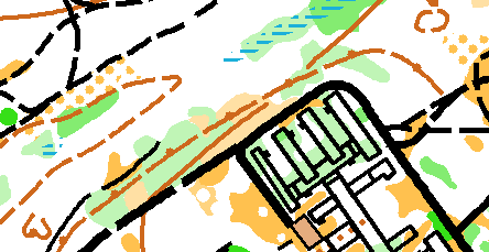
MAP INFO
Debert
ISOM
Scale: 1:7500
Contours: 5m
Size: 8.5" X 11"
New map: Jeff Teutsch, 2015
Elevation: 35m (approx)
Previous version of the map available here.
COURSE LENGTHS & DETAILS
Click here to see all the course details
TERRAIN DESCRIPTION
The southwestern half of the map is open pine forest with numerous trails. The northeastern section is more diverse with some of the same open forest mixed in with varying degrees of thicker woods. There are a multitude of interesting features in this area due to its military training area history. Time on these courses should be fast, but close contact to the map will need to be maintained as a small error could have big consequences!
OFFICIALS
Course planner: Tony Wheeler, HOC
Controller: Jim Blanchard. AVOC
ARENA INFORMATION
Vendors: The O-Store will likely be on site.
Food: Bring your own food & snacks, but here will be some available in the Arena.
Water: There will be limited water in the arena. Please bring plenty.
Toilets: There will be porta-potties on-site.
Distance & Time from Arena to Start: 1 minute.
Distance & Time to Arena from Parking: 250m max.
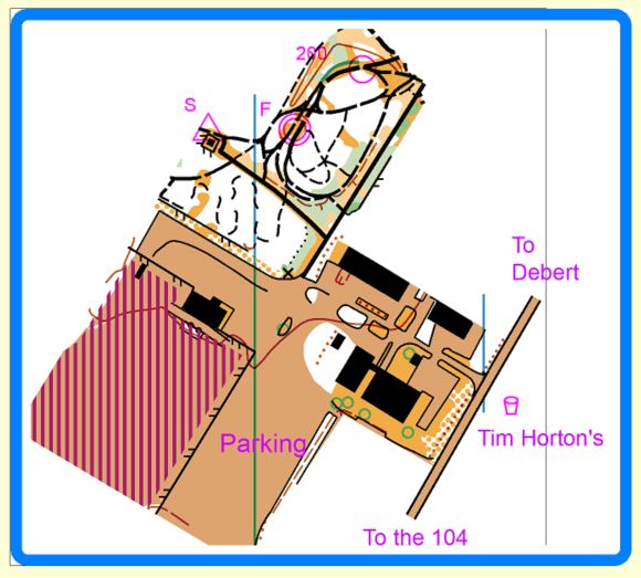
DIRECTIONS TO ARENA
The Debert Fishbones 3 race will convene at the Debert Industrial Park just off the 104 Trans Canada highway at exit 13. The parking area is only about 1 minute north on MacElmon Rd and then left onto Lysander Ave (across the road from a Tim Hortons. The start and finish area areas are only a two minute walk from the parking area.
The Debert Fishbones 3 race will convene at the Debert Industrial Park just off the 104 Trans Canada highway at exit 13. The parking area is only about 1 minute north on MacElmon Rd and then left onto Lysander Ave (across the road from a Tim Hortons. The start and finish area areas are only a two minute walk from the parking area.
RACE NOTES
Fishbones 3 will be a Chase Start, meaning that cumulative times from the Fishbones 1 and 2 races will be calculated and the fastest time in each course will be the first to start. The start times afterwards will be based on the total time behind the leader after FB 1 and 2. If you see someone in the woods who is on your course, chances are that you are at that point tied! The order that athletes cross the line will be their order of finishing. This should be a really fun race with a bit of pressure thrown into the mix. There will be five Point-to-Point courses and one Sport (Score) course.
Course 5 will have a map change at the finish area. There will be a separate chute for the change area with a control. This should be exciting for the rest of the orienteers who get to cheer on the course 5 runners at the mid-point of their race.
MAPPER NOTES
The woods around Debert have an extensive history as a second world war staging and training area known as Debert Military Camp and then in the 60s housed the maritime ‘Deifenbunker’. Much of this history is evident throughout the map with the remains of trenches, craters, and old military buildings providing a lot of unusual detail for orienteering. Craters and trenches have only been mapped if they are a metre or more in depth throughout most of the length or, in a few cases are simply too obvious to be left off the map. There are a variety of building remains on the east side of the map which consist of cement walls sticking out of the ground sometimes with a cement ‘floor’ covering a bunker. More recently, the area has seen heavy use by dirt-bikers and their tracks heavily criss-cross the area. These tracks range from large two-wheel rutted paths to tiny single-wheel tracks through the pines. Due to the open nature of the pine plantations bikers sometimes head off cross-country leaving obvious tracks in the soft ground. Any tracks that seemed to be of this ‘one-off’ nature were not mapped. A lot of the flat ‘plateau’ area is covered by pristine pine plantations allowing for fast running, but there is also a variety of thicker sections of forest throughout the map. These have, naturally, been mapped with various shades of green. It should be noted, however, that ‘green forest’ is proportionally fast, such that you can often run practically unimpeded through light green. Middle green will significantly slow you down but you should be able to get through without a huge amount of difficulty. There is very little dark green on the map.
Special features: Green Xs are large rootstocks (1.5m high) that stand out in the terrain. Smaller rootstocks are numerous and unmapped.
Black Xs: a variety of man-made objects, ranging from old appliances and machinery, to cement pillars (generally a metre high) to large signs have been mapped with black Xs.
