
COC Long distance
|

|
Saturday, August 22
Wentworth, Nova Scotia
SCHEDULE
Registration desk open: 9am
Start times: first start at 10 am - last start around 12:00
Max time allowed: 3 hours
Course closes: 3:00
Awards: 2:00 (approx)
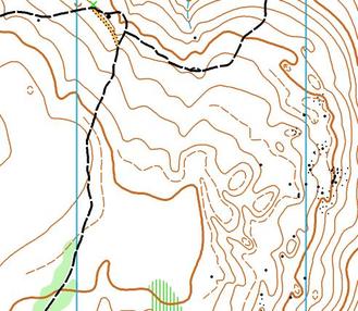
MAP SNIPPET & TERRAIN PHOTOS
Wentworth, Nova Scotia
SCHEDULE
Registration desk open: 9am
Start times: first start at 10 am - last start around 12:00
Max time allowed: 3 hours
Course closes: 3:00
Awards: 2:00 (approx)
MAP SNIPPET & TERRAIN PHOTOS
MAP INFO
Wentworth East
ISOM
Scale: M21, M35, W21 - 1:15,000. All other categories - 1:10,000
Contours: 5m
Size: 8.5" X 14" for courses on 1:10,000
8.5" X 11" for courses on 1:15,000
Updated: Bill Anderson, 2015
Elevation: 50m - 300m (approx)
Last major events: 2013 Fishbones
Existing map: Click here to see full image of previous map.
COURSE LENGTHS & DETAILS
Click here to see all the course details
TERRAIN DESCRIPTION
Open runnable hardwood forest, with pockets of thicker evergreen forest. Areas of lots with contour detail and areas with not many features at all. Very few rock features and boulders tend to be on the small size.
OFFICIALS
Course planner: Pam James
Controller: Greg Nix
IOF Event Advisor: Adrian Zissos, Calgary, Canada
ARENA INFORMATION
Vendors: O-Store
Food: A light snack will be available at the finish.
Water: Available at the finish and start.
Toilets: In the Ski lodge near the arena. No studs or muddy shoes in the Day Lodge!!
2 Port a Potties available 400 m from the start.
Distance & Time from Arena to Start: 1.7km with 160m of climb has been done in 25 minutes at a steady pace by the course planner.
Distance & Time to Arena from Parking: 100m max.
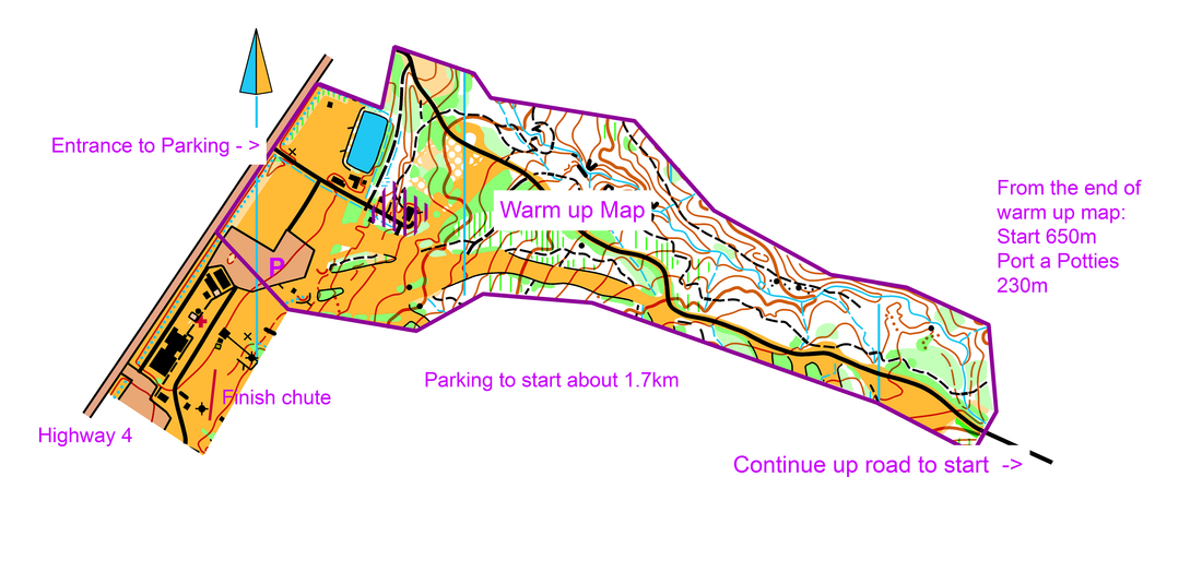
DIRECTIONS TO ARENA
The arena is at the base of the Wentworth Ski hill. Plenty of parking in the parking lot.
Arena webcam: www.novascotiawebcams.com/en/webcams/ski-wentworth/
Approximate travel times:
Halifax: 80 mins / Moncton: 70 mins / Amherst: 40 mins / Truro: 25 mins / New Glasgow: 60 mins.
RACE NOTES
Most of the climb will be done on the walk to the start.
MAPPERS NOTES
I trust you will enjoy the beautiful forest on the mountain as much as I did while updating the map. Boulders on the map are now all at least 1m high and rock faces 1m and vertical. I have used the solid line vegetation boundary on the ski hills to show the dramatic change with the forest. The solid line also delineates the small copses more effectively.
The runability green reflects the early summer conditions. White forest is often spectacular. Light green will be runnable but at reduced speed. Middle green will be very slow. Impassable green is to be avoided.
There are dozens of hydro poles, small towers, and light standards on the hill. The only ones I have drawn on the map are the large towers for the chair lift.
Many of the small "water channels" will be dry but are they are still very distinct.
That's it! Have fun! Bill Anderson
OTHER NOTES
M80, M85+, W75, W80, W85+ will be able to get a ride up to the Port a potties. This is approximately 400m from the start.
