
COC Sprint distance
|

|
Thursday, August 20
Charlottetown, Prince Edward Island
SCHEDULE
Registration desk open: 9:00 am
Quarantine: You must be in the quarantine area by 9:45am
Start times: first start is 10 am - last start around 11:15
Max time allowed: 60 minutes
Course closes: 12:30
Awards: 12:15 (approx)
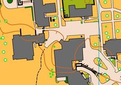
MAP SNIPPET & TERRAIN PHOTOS
Charlottetown, Prince Edward Island
SCHEDULE
Registration desk open: 9:00 am
Quarantine: You must be in the quarantine area by 9:45am
Start times: first start is 10 am - last start around 11:15
Max time allowed: 60 minutes
Course closes: 12:30
Awards: 12:15 (approx)
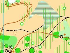
MAP SNIPPET & TERRAIN PHOTOS
|
|
MAP INFO
University of Prince Edward Island
ISSOM
Scale: 1:4,000
Contours: 2m
Size: 11 x 14"
New map: Jeff Teutsch, 2014
Elevation: 50m (approx)
COURSE LENGTHS & DETAILS
Click here to see all the course details
TERRAIN DESCRIPTION
A mix of university campus and forested areas.
OFFICIALS
Course planner: Charlotte MacNaughton, FWOC
Controller: David Ross, ONB
IOF Event Advisor: Adrian Zissos, Calgary, Canada
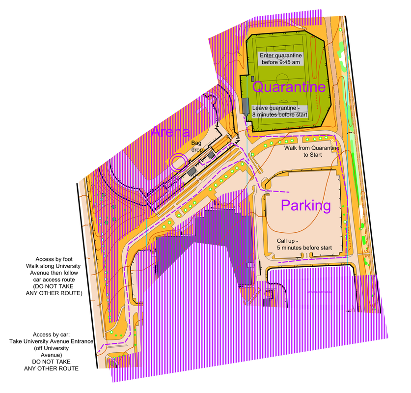
ARENA INFORMATION
Vendors: none on-site
Food: there will be limited snacks available at the finish. You can access food vendors in campus after your race
Water: there will be limited water available at the finish. Bring plenty with you.
Toilets: There are toilets in the spectator area of the track and in the quarantine area (no spikes allowed)
Distance & Time from Arena to Start: 500m max.
Distance & Time to Arena from Parking: 300m max.
EMBARGO
No one is permitted on the UPEI campus in the lead up to the race. The only exception is on the south end of the campus, where you can park in the most southerly parking lots and access the residence building as a number of orienteers will be staying at the UPEI residence. You are not permitted to go anywhere on campus aside from the most southerly parking lots, the Residence buildings and the Dining Hall.
QUARANTINE INFORMATION AND START PROCESS
There is a quarantine for this race. All competitors must be in the quarantine area by 9:45am. You may warm up in this area.
IMPORTANT: AUG 19 UPDATE TO QUARANTINE INFORMATION
You must still arrive and be in the quarantine by 09:45!
Quarantine has moved off the soccer field (too hot -- no shade) into one of the gyms near the race arena. Watch for signs directing you when you arrive.
Parking and access routes have not changed.
We will have access to the indoor track for warmups.
DIRECTIONS TO ARENA
Access by car:
Enter the campus at the University Avenue Entrance then follow the map below to the parking.
Parking will be in the lot immediately south of the soccer stadium.
Access by foot:
Walk along University Avenue then follow the "Access by Car" directions.
Before entering the quarantine area you will be able to enter the arena to drop off bags (since you can't enter quarantine after your race until everyone has started their race).
University of Prince Edward Island
ISSOM
Scale: 1:4,000
Contours: 2m
Size: 11 x 14"
New map: Jeff Teutsch, 2014
Elevation: 50m (approx)
COURSE LENGTHS & DETAILS
Click here to see all the course details
TERRAIN DESCRIPTION
A mix of university campus and forested areas.
OFFICIALS
Course planner: Charlotte MacNaughton, FWOC
Controller: David Ross, ONB
IOF Event Advisor: Adrian Zissos, Calgary, Canada
ARENA INFORMATION
Vendors: none on-site
Food: there will be limited snacks available at the finish. You can access food vendors in campus after your race
Water: there will be limited water available at the finish. Bring plenty with you.
Toilets: There are toilets in the spectator area of the track and in the quarantine area (no spikes allowed)
Distance & Time from Arena to Start: 500m max.
Distance & Time to Arena from Parking: 300m max.
EMBARGO
No one is permitted on the UPEI campus in the lead up to the race. The only exception is on the south end of the campus, where you can park in the most southerly parking lots and access the residence building as a number of orienteers will be staying at the UPEI residence. You are not permitted to go anywhere on campus aside from the most southerly parking lots, the Residence buildings and the Dining Hall.
QUARANTINE INFORMATION AND START PROCESS
There is a quarantine for this race. All competitors must be in the quarantine area by 9:45am. You may warm up in this area.
IMPORTANT: AUG 19 UPDATE TO QUARANTINE INFORMATION
You must still arrive and be in the quarantine by 09:45!
Quarantine has moved off the soccer field (too hot -- no shade) into one of the gyms near the race arena. Watch for signs directing you when you arrive.
Parking and access routes have not changed.
We will have access to the indoor track for warmups.
DIRECTIONS TO ARENA
Access by car:
Enter the campus at the University Avenue Entrance then follow the map below to the parking.
Parking will be in the lot immediately south of the soccer stadium.
Access by foot:
Walk along University Avenue then follow the "Access by Car" directions.
Before entering the quarantine area you will be able to enter the arena to drop off bags (since you can't enter quarantine after your race until everyone has started their race).
RACE / COURSE SETTER NOTES
- The Top Canadian in the Men & Women elite classes will automatically be selected to run for Canada at the 2016 World Championships Sprint races in Sweden. For full details see the 2015/2016 Senior National Team Selection document on the Orienteering Canada website.
- Footwear > Shoes with spikes are not permitted in this race.
- Clothing > It is appropriate to wear shorts / have uncovered legs during this race if that is your desired clothing choice.
- Course distance > the course distance has been calculated using the shortest runnable route, not the straight line distance.
- A reminder that you may not step foot in any out of bounds/olive green areas. Be prepared to be disqualified or disqualify yourself if you do.
- As is common with university campuses during the summer, there may be some areas of construction/landscaping projects that are not marked on the map.
- Remember that there are other events/conferences/day to day campus life happening. Be respectful and courteous. Share the campus with other users, it is not ours to use exclusively. And as always watch for vehicles and be careful when crossing roads.
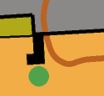
- The course setter has added some artificial barriers to enhance various route choices. These are marked on the map with the purple uncrossable barrier symbol (a thick purple line) (see below for example) and will be marked in the terrain with stakes and flagging tape.
- A commonly used cross description is the junction of a building and a wall. Below is an example of the control description and an example of the map illustrating the control description.

Example of artificial barrier added to map
Example of wall and building junction

Example of wall and building junction course description
MAPPER NOTES
The University of Prince Edward Island was mapped in mid-November 2014 from base material provided by the City of Charlottetown. The area was re-checked sprint/summer 2015.
The map is a typical university campus with buildings with complex detail around entrance ways, lots of treed lawn, paved pathways and small patches of garden. Both symbols 421, impassable vegetation (extra dark green), and 527, area with forbidden access (olive green) are used to mark cultivated vegetation that are illegal to pass through. If the vegetation is physically difficult to pass through (e.g. a hedge) then it is mapped with 421. If the vegetation is physically easy to cross through (e.g. a garden patch) then it is mapped with 527. 527 is also used to map private property. Small gardens are additionally surrounded by cultivation boundary symbol 414 (a thin black line) to improve their visibility on the map. There are also numerous power transformers and other large man-made features throughout the campus which have been mapped to shape in black. Smaller man-made features such as salt-boxes are not mapped.
